Groundwater Supply
Waters Without Frontiers has these services and products available
Groundwater Supply
Groundwater contributes more than 80% of potable water supply to rural communities in Southern Africa. Waters Without Frontiers has extensive experience in the identification and development of groundwater resources for water supplies. The company’s expertise includes among others, the following:
Remote Sensing for borehole siting
The company uses latest satellite images and aerial photographs to identify lineaments associated with geological structure that influence groundwater occurrence and movement. We also use drone technology to carry out quick site reconnaissance to zoom in on interesting features on the ground.
Geophysical survey
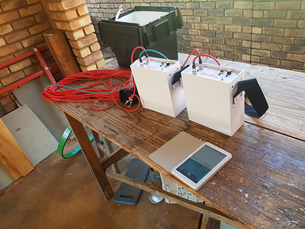
The company employs three complimentary geophysical survey techniques, consisting of electromagnetic (EM) and magnetic traverses, and electro-seismic soundings.
Electromagnetic traverses are conducted to locate conductive saturated fracture zones and faults. A PCFDEM-24Bit frequency domain electromagnetic instrument was used. Boasting eight frequencies, the instrument takes eight measurements at each station, with each measurement corresponding to a different frequency. Each frequency in turn, corresponds to a different depth of ground penetration. The higher the frequency, the lower the depth of ground penetration and vice versa. The instrument can achieve ground penetration depth in excess of 300 metres. The instrument allows for the measurement of ground electrical conductivity variations in both the horizontal and vertical directions; thus enabling the production of two dimensional vertical conductivity sections or pseudo-sections.
Magnetic traverses are conducted to locate contacts between dolerite intrusion and the host rocks. These contacts are characterised by significant fracturing as explained earlier. Magnetic traverses were conducted along the same lines and station spacing as EM traverses.
Electro-Seismic Survey theoretically can pick the presence of a water table. The technique is based on the principle that when a seismic wave generated at the surface reaches the water table in permeable rock, the water is forced to move relative to its rock surroundings as the pulse passes. This motion creates a small electrical pulse that is measurable at the surface by pairs of electrodes close to the shot point. The technique is still at its infancy in South Africa; hence is being explored. Water strikes are indicated by spikes on seismic traces.
Ground Water Development
- Borehole drilling supervision and construction design,
- Pumping test design and supervision,
- Determination of long-term sustainable exploitation of groundwater,
- Groundwater quality assessment,
- Spring protection design and construction supervision,
- Facilitation of groundwater use licence application,
- Simulation of aquifer response to different exploitation scenarios using groundwater-modelling software.
Emergency Water Supply
One of the most important needs for communities hit by disasters, whether natural or man-made, is the provision of emergency safe and clean drinking water immediately after the disaster. Waters Without Frontiers has capacity to:
- Assess water requirements of communities hit by the disaster,
- Identify and mobilise emergency water supply resources to alleviate human suffering. Such resources include:
- Trailer mounted mobile water purification plants,
Lifesaver bottles that have a filter which can make the most revolting water drinkable in seconds, enabling the use of water directly from the river.
Anti-bacteria tablets.
- Tanker trucks to affected communities